Geologic Features of Southern Ontario
Contents
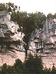
Niagara Escarpment
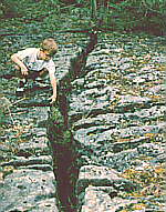
 The
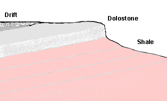
figure at right shows tilted sedimentary strata, and a surface of erosion
forming a steep escarpment. This depicts the Niagara Escarpment in southern
Ontario. The rock forming the cliffs consists of a dolomitic limestone.
It overlies a softer red shale called the Queenston Shale. The Niagara
Escarpment is a prominent landform in southern Ontario, extending from
Niagara Falls to the northern islands of Lake Huron.
The
figure at right shows tilted sedimentary strata, and a surface of erosion
forming a steep escarpment. This depicts the Niagara Escarpment in southern
Ontario. The rock forming the cliffs consists of a dolomitic limestone.
It overlies a softer red shale called the Queenston Shale. The Niagara
Escarpment is a prominent landform in southern Ontario, extending from
Niagara Falls to the northern islands of Lake Huron.
Where tilted sedimentary strata have been planed off, so that the rock formations terminate in the air, as shown in the figure, this is evidence for erosion. What was the nature of the erosion - catastrophic, or was it caused by weathering, solution, and other existing processes over long ages?
Two centuries ago this fundamental question about the rate of geologic change was the center of controversy amongst geologists. James Hutton of Edinburgh (1726-1797) claimed the earth's geologic features are the result of existing processes, and former catastrophes are not required; however, Sir James Hall (1761-1832) pointed out deficiencies in the claims of Hutton and Playfair, and described excellent evidence for catastrophic erosion. Hall wrote [Hall, James, 1812. On the Revolutions of the Earth's Surface, Part 1. Transactions of the Royal Society of Edinburgh, vol v, 139-167; see p. 140.] :
I have no hesitation in declaring my hearty concurrence in what I consider as the essence of the Huttonian Theory; I mean as to all that relates to the influence of internal heat in the formation of our rocks and mountains: But I could never help differing from Dr HUTTON, as to the particular mode in which he conceived our continents to have risen from the bottom of the sea, by a motion so gentle, as to leave no trace of the event, and so as to have had no share in producing the present state of the Earth's surface.Sir James Hall agreed with Hutton about the importance of subterranean heat, but rejected the notion that existing processes could have caused all the erosional features of the earth's surface. He described evidence for violent, catastrophic currents, in the region around Edinburgh. He claimed the streamlined hills, now known as drumlins, were caused by vigorous currents, generated by tectonic movements on the ocean floor, that had swept over the land. And Hall's views about the mechanisms involved in the formation of streamlined hills have recently been vindicated.
Sir Charles Lyell (1797-1875) defended the ideas of Hutton, and argued that existing processes were sufficient to explain the features of the earth's surface. He became one of the most influential geologists of the nineteenth century. Trained as a laywer, he was a skillful advocate for his chosen cause. He rejected violent, catastrophic agents of erosion in the earth's past, such as those invoked by Hall. During a visit to the United States, Lyell went to Niagara Falls where he investigated the rate of retreat of the falls, and he believed he found evidence to support his theory. The falls had been eroding back from the escarpment at Queenston, Lyell estimated, for about 35,000 years.
The doctrine of uniformitarianism advanced by Hutton, Lyell and their followers is becoming recognized as an unfounded assertion. But it was taught for many years while every attempt was made to discredit the catastrophic alternative. Lyell's rhetoric had a profound affect on the develoment of geology and its influence is still with us.
The missing strata in the figure above is evidence
for great erosion. Several features in areas near the Niagara Escarpment
point to differential crustal uplift, which generated powerful currents
in an environment of catastrophic flooding, as the cause:
|
Each of the above mentioned features are present in the Great Lakes region, in southern Ontario, and most are also present in northwestern New York, associated with the Niagara Escarpment. Some of them are also present around the perimeter of the Canadian Shield west of Hudson Bay. Uplift was centered in the Canadian Shield, and the water flowing off uplifted regions eroded the sedimentary cover from the Shield and surrounding areas.
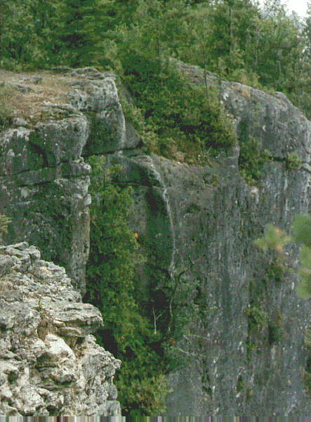
Missing Talus
 There
is very little talus beneath the high cliffs of the Niagara Escarpment
in many areas; however large blocks of rock that have come from the escarpment
can be seen in the waters of Georgian Bay, for example at Lion's Head.
These are not properly called talus, but are really intact blocks
of dolomitic limestone that have been undermined by erosion of the substratum.
Glacial ice would not undermine the rock in this fashion.
There
is very little talus beneath the high cliffs of the Niagara Escarpment
in many areas; however large blocks of rock that have come from the escarpment
can be seen in the waters of Georgian Bay, for example at Lion's Head.
These are not properly called talus, but are really intact blocks
of dolomitic limestone that have been undermined by erosion of the substratum.
Glacial ice would not undermine the rock in this fashion.
The photo at right shows a view of the overhanging cliffs of the Niagara Escarpment at Lion's Head. If the escarpment had been eroded by existing processes over millions of years, as most geologists suppose, one would expect much more talus east of the escarpment. If a vast ice sheet had swept over the escarpment, fragile rock pinnacles and overhanging ledges would have been destroyed, and where there are deep fissures, the rock would probably have been broken up and eroded away.
The catastrophic approach can explain the missing talus. In Ontario, the escarpment was eroded by currents flowing from the northeast to southwest, or east to west in the region near Lake Ontario. Flow was from the low side. This is shown by the orientation of drumlins back from the escarpment, in areas such as the Bruce Peninsula north of Wiarton, south of Meaford, and at Westover, near the western end of Lake Ontario. These currents were probably generated by various differential crustal uplifts centered in the Canadian Shield, and subsidence of the Michigan and Allegheny sedimentary basins. I suggest the catastrophic currents which excavated the deep basins of Lake Ontario and Georgian Bay eroded the Niagara Escarpment and its major valleys, Colpoys Bay, Owen Sound, Beaver Valley, and Dundas Valley.
Niagara Falls
At Niagara Falls, several spillways and former cataracts indicate catastrophic conditions prevailed when the gorge of the Niagara River was eroded. Also, the submerged channel from the Niagara River extends far out into Lake Ontario. |
|
|
The gorge of the Niagara River has a complex history. During construction of railway bridges, drift gravel was found deep below the present Niagara River, beneath the talus blocks that have fallen down from the sides. Before this discovery, geologists had assumed the gorge had been eroded by a progressive slow retreat of the falls upstream, due to a "sapping" process at the falls, which undermined the harder dolomitic limestone above softer shale and sandstones, leading to periodic collapse of the limestone. Charles Lyell estimated 35,000 years were required for the formation of the gorge, and numerous other estimates have been attempted.
The presence of drift gravel below the river bed showed the river had eroded unconsolidated drift gravel and sand, like that which remained below the present river bed, rather than hard rock. This erosion of the gorge could occur much more rapidly than Lyell had claimed.
At least five cataracts, similar to the present one, spilled over the Niagara Escarpment, before the present gorge was excavated. Evidence for these former outlets exists at Holley, Medina, Gasport, Lockport, and Lewiston, all in NY. These outlets were associated with an ancient lake called Lake Tonawanda; this lake probably existed for only a brief period during the drainage of a former much larger Lake Erie, as the land was uplifted.
The drainage from the Lake Erie basin became confined to its most westerly outlet as the Niagara gorge was excavated. Most of the present gorge was probably eroded by a much larger volume of water than the present Niagara River. Traces of the former river bed can be found at various sites, high above the present river; for example at Niagara Glen. Smeaton Ravine, on the Canadian side, was the site of a small, temporary waterfall, 46 m wide. This torrent eroded a gorge 152 m long, and emptied into the Niagara River. The former more powerful currents probably eroded most of the gorge in a relatively short time span.
Conventional theory says a pre-glacial river eroded the upper part of the Niagara River Gorge, and the St David gorge, but this gorge was filled up with glacial drift by the glaciers. The pre-existing channel was partly re-excavated by the existing Niagara River.
A new alternative explanation is that the drift within the Niagara Gorge was formed by an in situ disintegration process, during the retreat of the flood waters, when the basins of the Great Lakes were excavated by the fast currents generated by tectonic movements. This unconsolidated drift sand and gravel of the Niagara Gorge was excavated by retreating flood waters that drained the Lake Erie basin. At the Whirlpool, the course of the ancient drift filled valley split; one part was excavated by the currents, and the other remained unexcavated. The filled valley, 300 m wide and about 90 m deep, is the St. David buried gorge. [See map.] Well log data indicates other similar buried valleys occur below the surface in the area of the present town of Niagara Falls in Ontario. Some of these are upstream from the site of the present falls.


Mystery of Pothole Origins
On the Interpretation of Potholes
Pillars, Polystrate Formations, and Potholes
The Drift
The motivation underlying the adoption the glacial theory in the last century was that it more easily fit the uniformitarian dogma of James Hutton, who suggested that rounded pebbles had come from older rocks; it was "from the decay and revolution of these Secondary strata, in the wasting operations of the surface, that have come those round siliceous bodies which could not be thus worn by travelling in the longest river." (Theory of the Earth, vol. 2, 1795; p.144, note.)Assumptions about the origin of the pebbles and boulders of the drift were crucial; the notion that all the pebbles and sand grains of the earth were eroded from older rocks, during prolonged exposure at the earth's surface, is the essence of Hutton's theory. The glacial theory of Louis Agassiz merely provided what was deemed a more vigorous and powerful means of eroding and transporting rocks, scratching bedrock, building landforms, etc.
Rev. William Buckland (1784-1856) became Professor of Mineralogy and of Geology at Oxford, and was later appointed Dean of Westminster. Charles Lyell was one of his students. Buckland advocated a diluvial theory of the drift, but he agreed with Hutton about the break up of rocks during exposure at the earth's surface, their being rolled about, and transported by currents. Lyell thought the pebbles had been distributed by being "drifted" around by icebergs during a prolonged period of submergence; hence the term "drift". There was thus an affinity between Buckland, Agassiz, and Lyell, even though they each advanced different interpretatons of the drift; they shared the axioms of Hutton about the interpretation of the stones and pebbles.
Creationists today who support a post-flood Ice Age as the explanation of the drift probably share to some extent the same axiom, that all the pebbles of the earth were rounded and smoothed by being rolled about at the earth's surface, which is the basis of Hutton's uniformitarianism.
The disintegration theory is an alternative explanation which does not rely on Hutton's axioms. It claims the pebbles and boulders were formed in place, by chemical processes of precipitation during rapidly changing conditions when sediments were being compacted, and there was erosion of overburden by retreating currents of the flood. It is based on observations of the configuration of the sandy strata around embedded pebbles, which prove the strata in the cross-stratified drift has a non-sedimentary origin; the strata around embedded pebbles does not show directional "stoss-and-lee" effects, current shadows, (elongated ridges on the lee side of pebbles, etc.) The lack of these effects proves a non-sedimentary origin of the patterns of cross strata in the drift. The pebbles and oulders contain internal evidence of concretionary development. There is often concentric structure, or the pebbles may have composition and texture that varies from that of available source rocks. Numerous other features also suggest the boulders have not been transported as is assumed in conventional interpretations.
The in situ disintegration approach seems to have been suggested by Robert Jameson (1774-1854), who was the leader of the Neptunist school in Britain. The Neptunists promoted the views of Abraham Gottlob Werner (1750-1817), teacher at the school of mines in Freiberg, against the supporters of James Hutton.
Jameson went to Freiberg in 1800 and studied under Werner for nearly two years. In 1804 he became professor of Natural History at Edinburgh University.
William Buckland opposed the views of Neptunists like Jameson. In a letter to Greenough, now in the Cambridge, Buckland wrote in 1817 [See Rupke, N.A. 1983. The great chain of history. Clarendon Press, Oxford. p. 119]:
In Bath I attended two lectures of a young disciple of Jameson, Dr. Galby who is very promising. He gave us Jameson's last theory of the coal formation, which is that all the substance of coal as well as the strata attending it is of chemical origin and unconnected with vegetable matter and that whin dykes are contemporaneous concretions in the rocks they transverse. The whole theory of denudation is to him terra incognita. All pebbles in every species of conglomerate are considered as contemporaneous concretions, with sundry other monstrous opinions which at this time of day astonish me in Jameson.Jameson apparently eventually converted to the views of James Hutton.
The "monstrous opinions" about conglomerates referred to above were
at variance with the views of Hutton, and were evidently not developed
further. But the in situ approach to the origin of the drift also
helps us to explain conglomerates buried under other sediments. Their pebbles
need not have rolled about at the surface for long ages, which is incompatible
with their origin in a global flood. The disintegration theory remains
a very promising approach, and a fruitful area for investigation and discovery.
Cross Strata Anomalies
More Pages
Giant Current Ripples on Ontario's Bruce PeninsulaDrumlins and Diluvial Currents
The Great Lakes and the Flood
Directional Erosion Evidence in Lake Huron
Controversy about the Glacial Theory
Related Links
The Niagara Escarpment -- An Earth Chronicles EpisodeNiagara Falls: Origins
A Geological History of the Niagara Region
Niagara and the Age of the Earth by geologist C. Gordon Winder