Directional Erosion Evidence in Lake Huron
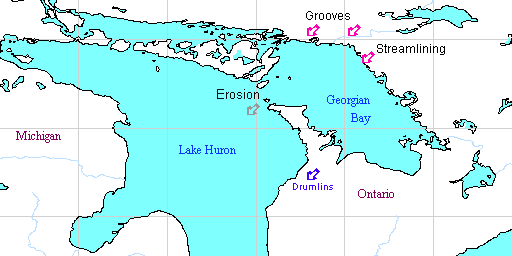
Several directional erosion features are marked in this map of Lake Huron and Georgian Bay and surrounding land, and others are indicated by the shape of the coastlines. In the lower Bruce Peninsula, the local direction of orientation of the drumlins is shown by the blue arrow pointing southwest. They are aligned parallel to the "re-entrant" valley of Colpoy's Bay, and the drumlins further east in Southern Ontario are also aligned parallel to the axes of local re-entrant valleys of Owen Sound, Beaver Valley, and others.
On the north shore of Georgian Bay, indicated on the map by the pink arrows, there is abundant evidence of extreme erosion, such as grooves, flutes, troughs, potholes, and various streamlined and sculpted landforms in Precambrian bedrock that geologists Kor, Shaw, and Sharpe attribute to catastrophic flooding due to the release of an enormous reservior of subglacial meltwater. They estimated the flow rates during the formation of these directional erosion features to have been of the order of 107 m3/s, and comparable to the discharge rates estimated from glacial Lake Missoula and other great floods known from geologic evidence.
However, ponding of huge amounts of meltwater beneath an ice sheet, such as they postulate, would be unlikely, and another explanation of this erosional evidence is neeed when all the erosional evidence is reinterpreted without invoking the glacial theory. The erosion of the rock basins of the Great Lakes and other lake basins can be explained in a catastrophic flood environment. Directional features provide evidence of former currents responsible for the formation of the rock basins of Lake Huron, and Georgian Bay, and other Great Lakes, and the Niagara Escarpment.
In the map above, the grey arrow in Lake Huron, aligned with the straight between the northern tip of the Bruce Peninsula and Manitoulan Island, is marked "Erosion". The widest part of this straight is known as Main Channel. The "Erosion" label on the map is intended to highlight an area where the height of the Niagara Escarpment is relatively low, so that it lies submerged beneath the waters of Lake Huron, indicating that this is a region where erosion was intensified. This apparent gap in the continuity of the Niagara Escarpment between Tobermory on the Bruce Peninsula and Manitoulin Island is directly in line with the flow directions of former catastrophic currents from the northeast that caused the directional features on the north shore of Georgian Bay described by Kor et al. Here, in the island strewn straight, erosion by a former ice sheet seems most unlikely since the islands, Cove Island, and others, would no doubt have resisted the movement of a vast ice sheet over them. The same argument presents a serious objection to the idea of ice erosion as the cause of re-entrant valleys such as Colpoy's Bay.
 On
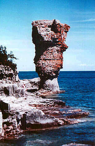
one of the islands off the north coast of the Bruce Peninsula, Flowerpot
Island, there are two unstable stacks or pillars of fractured rock, standing
on the eastern shore, a location which would have received maximum wear
and tear from the supposed movement of a hypothetical ice sheet over the
region. Presumably, the ice would have to sweep up and over the escarpment
from the depths of Georgian Bay, leaving these rock pinnacles intact! The
presence of these stacks seems to discredit the idea of former ice sheets
in the region of Georgian Bay.
On
one of the islands off the north coast of the Bruce Peninsula, Flowerpot
Island, there are two unstable stacks or pillars of fractured rock, standing
on the eastern shore, a location which would have received maximum wear
and tear from the supposed movement of a hypothetical ice sheet over the
region. Presumably, the ice would have to sweep up and over the escarpment
from the depths of Georgian Bay, leaving these rock pinnacles intact! The
presence of these stacks seems to discredit the idea of former ice sheets
in the region of Georgian Bay.
The rocks missing from the Niagara Escarpment in this area seem to have been eroded away by former fast currents. The current flow generated by a crustal uplift in the northeast would tend to maximize erosion once the escarpment was breached. Another indication that this has occurred in the area is the maximum depth in Georgian Bay is just off the northern shore of the Bruce Peninsula, on the southern border of the straight, where the cliffs of the escarpment are quite high. They would have deflected the current flow here, thus causing deepening of the lake.
There are many indications of erosion by fast currents on both sides of the straight. On the Lake Huron shore of the Bruce Peninsula, at Dorcas Bay and in other areas, and near South Baymouth on Manitoulin Island as well, the dolostone bedrock appears deeply grooved, scoured, and streamlined by the fast currents, and the direction of the scouring and streamling here corresponds with the other directional indicators mentioned above.
Another directional indicator, which corresponds with this evidence for erosion by currents, is the tilt of the ancient high shorelines which have left a series of beaches and bluffs around Georgian Bay, which reach greater elevations in the northeastern shore. Crustal uplift centered in areas lying towards the northeast of Georgian Bay has since elevated these ancient shorelines.
Furthermore, also corresponding with all the previously mentioned directional erosion indicators, there is the direction of the dip of the Niagaran rocks which form the Niagara Escarpment. The sediments of the Michigan Basin form a saucer shape, with the Niagara Escarpment being represented by the rim. In the Bruce Peninsula, and in most of Southern Ontario, the Niagaran rocks dip at about 30 feet/mile to the southwest, which corresponds with other directional indicators in the Bruce Peninsula. This is highly significant, as it implies the differential crustal warping which formed the Michigan Basin, and raised ancient elevated shorelines around Georgian Bay, and all the evidence for erosion by fast currents in the area, can be related to the same general cause: at the end of the flood, uplift centered northeast of Georgian Bay, perhaps in the Abitibi Upland of the Canadian Shield, spilled overlying flood waters to the southwest, a region which was subsiding, and which was therefore an area of sediment accumulation. The rapid flow of these currents probably removed enormous amounts of sediment from the Shield, leaving some of it behind as outliers in ancient rock basins and low areas, and excavated the deep lake basins aligned along the perimeter of the Canadian Shield.
See Also:
Giant Current Ripples in Ontario's Bruce PeninsulaThe Great Lakes and the Flood
Mystery of Pothole Origins
Sir J. W. Dawson's Dissent from the Glacial Theory
Raphael Pumpelly on secular rock disintegration
Michigan's Fossil Whales
Drumlins and subglacial meltwater floods
Drumlins and Diluvial Currents
Problems in the Glacial Theory
References
Kor, P. S. G., J. Shaw, and D. R. Sharpe (1991) Erosion of bedrock by subglacial meltwater, Georgian Bay, Ontario: a regional view. Canadian Journal of Earth Science 28:623-642.Straw, A. (1968) Late Pleistocene glacial erosion along the Niagara Escarpment of Southern Ontario. Geological Society of America Bulletin 79:889-910.
Related Links
Bathymetry Map of Lake HuronCopyright © 1997 by Douglas E. Cox
The Creation Concept | Controversy
About the Glacial Theory