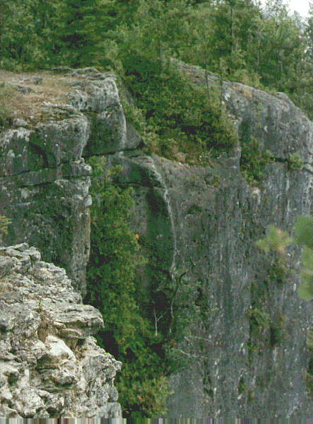
Eagle's Nest PotholesAlong the top of the spectacular cliffs of the Niagara Escarpment in Ontario there are several locations where potholes occur. On the Bruce Peninsula, a large pothole is exposed in the face of the cliff near Lion's Head. It is locally known as the "Eagles' Nest" because of several rounded boulders that remain in it, that are visible from boats on the lake. Its location is in the center of the cliff in the photo at right. |
 |
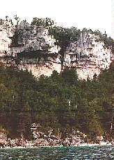 |
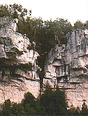
These two photos show the location of the potholes depicted on this page in a high cliff overlooking the lake. The 'Eagle's Nest' is a pothole in the cliff face behind the trees, overlooking Isthmus Bay near Lion's Head. It is associated with several smaller potholes. |
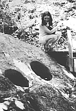
| The map at right shows the location of the village of Lion's Head, at latitude 45o North on the eastern shore of the Bruce Peninsula. Potholes are found on the cliffs of the Niagara Escarpment nearby. |  |
 |
According to the conventional uniformitarian explanation of potholes found in many geology text books, potholes like these were caused by vortices in former streams that rotated and vibrated "grinding stones" over long ages of time, the process gradually wearing down a deep, cylindical hole into the rock. In this case, however, the circumstances seem to discredit this explanation. Of course it is unlikely vortices could have existed high on the face of a steep cliff, and rotation could not be maintained in a hole if one side of it was missing. |
 |
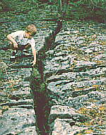
The picture at left shows portions of two potholes that
intersect,
at the top of the cliff near the site of the previous pothole.
It is common to find partial potholes, where only a portion of a vertical cylindical hole remains in the side of a gorge or cliff. The theory of vortices whirling those grinding stones appears absurd when one tries to imagine how the stones could be down in the holes whirling around and around where one wall of the pothole was missing. And with part of the wall of a pothole missing, how could the currents have continued to circulate? What would keep the "grinding stones" from falling out, and tumbling down the cliff? |
 |
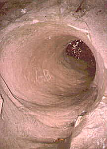
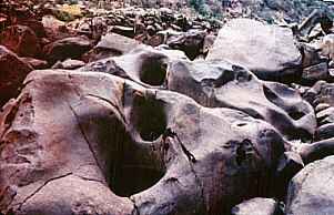
The image at left is a view looking down into one of the potholes from above. Some large rounded boulders are present in the pothole. |
 |
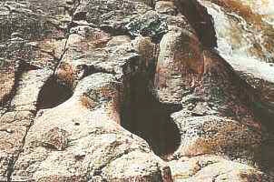
The boulders of the "Eagle's Nest" can be seen in the
potholes in this
photo. If there were a waterfall tumbling down the cliff here, no doubt
many would assume the water had eroded the potholes. But in this
location,
no waterfalls are likely to have existed long enough to erode
them.
Rivers may have removed partially unconsolidated material, and sand, gravel, or drift, from potholes, and are often still doing so today. My research indicates the rivers had nothing to do with forming the potholes, but merely exposed them. The conditions in which the potholes formed were unlike those of the present. Potholes in some rocks probably formed during compaction, as joints formed in the rock. Many of the intersecting potholes are aligned along joints. |
 |
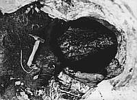
Another pothole near the top of the escarpment which opens into the larger Eagle's Nest pothole. A small tree is growing inside the pothole. |
 |
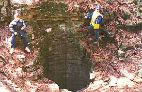
View from the top of the cliff at the Eagle's Nest, looking down. Note the boulders and gravel in the pothole. |
| The dolomite rock of the Niagara Escarpment where these
potholes occur
is part of the Amabel formation.
The rock is deeply fissured, and because of this, there are no surface streams in the area that could have eroded potholes. The distribution of the potholes does not suggest the action of streams, as they are scattered over a wide area above the escarpment. Many potholes are situated in locations that seem unlikely to have ever been the sites of former streams. |
 |
 |
The view along the rugged and scenic cliffs of the Niagara Escarpment, looking west towards Lion's Head harbor in the distance. |