Peculiar Potholes at Lion's Head
The cluster of potholes is locally called the "Eagle's Nest", probably because some of them retain large rounded boulders, and viewed from a boat in the lake, they suggest collections of large eggs in a nest high in the cliffs. In the photo at right, boulders are present at two levels. These are the remnants of a gravel fill similar to that which is eroding out of the innermost potholes.

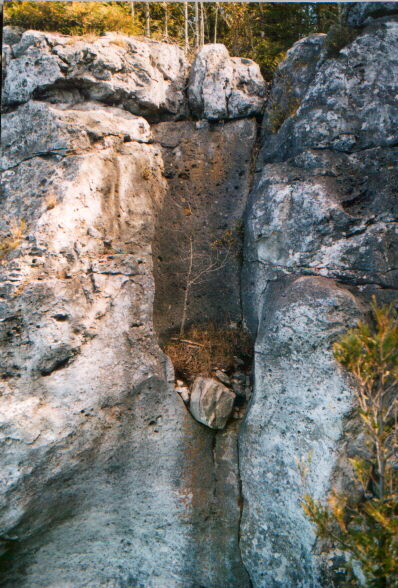
Note the joint at the right, which probably controlled the location of these potholes. Large, well rounded boulders are shown at the bottom of this photo and the one below. These boulders rest partly on the gravel and boulder fill of yet another mostly filled pothole, and some are supported by a thin natural arch of rock, not visible in this photo, beneath the boulders. It forms a bridge between the sides of the pothole. This rock arch is probably an extremely delicate feature and seems to discredit the idea that such large boulders could have been introduced from outside, as conventional interpretations assume, because it could not have withstood the impact of big boulders.
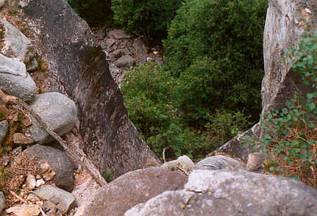
There is active erosion here, and real danger that boulders could come crashing down the cliff at high velocity through the forest and into the lake below. It would be a great pity if this were to cause the destruction of the fragile and unique rock arch which is being exposed by erosion of the gravel in the upper section of the pothole.

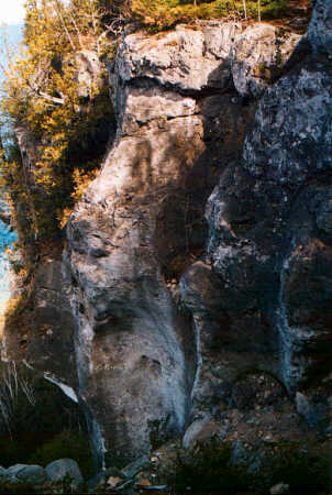
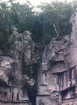
 Another
partial pothole to the left of the previous photo is shown here.
Tops of trees on the scree slope at the bottom of the cliff, and water
of the lake are visible on the left.
Another
partial pothole to the left of the previous photo is shown here.
Tops of trees on the scree slope at the bottom of the cliff, and water
of the lake are visible on the left.
One of the puzzling questions about the Eagle's Nest landmark is the origin of the boulders. They look like foreigners, since they are composed of silicate minerals, and the rock in which the potholes occur is a carbonate rock, the Silurian Amabel Formation, consisting of dolostone. The escarpment in this area is formed of the Wiarton/Colpoy Bay member [Kor 1992, p. 1]. One theory is that the boulders were carried across Georgian Bay by ice. Why would the ice sheet have placed them in the deep potholes high on a cliff?
Could the boulders have been tools for drilling the potholes? Many people assume they were, but they seem to be a bit too big to have been swirled around inside the potholes. Most of them are rounded and smooth. However, at least one of the boulders is not rounded. How could boulders being swirled around by currents have drilled the holes, since part of their walls are missing? Why would the boulders not have crashed down the cliff? According to one explanation, the missing wall of the potholes was supplied by the ice. However, ice would be a lot softer than rock, and would be melted by the heat generated by friction, so this seems unlikely to explain intersecting potholes.
 Traditional
theories advanced to explain partial potholes in the cliffs of the Niagara
Escarpment involved subaerial flow at a time when ice stood alongside the
escarpment, or solution processes. Ice would probably be far too soft for
the drilling to work, and there is little evidence in support of solution
as the cause of these potholes.
Traditional
theories advanced to explain partial potholes in the cliffs of the Niagara
Escarpment involved subaerial flow at a time when ice stood alongside the
escarpment, or solution processes. Ice would probably be far too soft for
the drilling to work, and there is little evidence in support of solution
as the cause of these potholes.
Erosion of potholes on both sides of Georgian Bay has been attributed to catastrophic currents of a subglacial meltwater flood [Kor et al, 1991; Kor, 1992; Kor and Cowell, 1998]. These currents are thought to have been pressurized by the weight of the ice sheet. However, the volume of water available in this hypothesis seems limited, as it is thought to have affected large segments of the Niagara Escarpment, causing erosion and streamlining effects from Manitoulan Island to Blue Mountain, eroding the indentations or re-entrants of Colpoys Bay, Owen Sound and Beaver Valley, and streamlining the regions beyond, west of the escarpment. Shoemaker referred to the inadequate supply of water as a major problem for the subglacial meltwater flood hypothesis [Shoemaker 1991, p. 1250]. Because it is believed to have extended over such a wide area, the catastrophic flow from a meltwater reservoir beneath an ice sheet would probably be insufficient for maintaining a steady flow, long enough for drilling deep potholes in hard rock. It would have to be a short-term event, lasting only days or weeks [Kor, 1992, p. 12].
The presence of potholes and large erratic boulders high on the cliff seems anomalous. Because of the instability of large boulders in a high cliff face, they tend to fall from their precarious locations. From the point of view of conventional pothole interpretations, their location in a high cliff, and the accumulation of boulders and emplacement in such positions seems unnatural and strange.
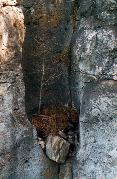
 The
photo at left shows the curved surface of the west wall of the outer pothole,
and the top of the narrow rock arch or bridge on the left of the picture,
with several boulders resting on it. Since this photo was taken there has
been erosion of the loose material shown here. A hole has appeared left
of the arch which will probably accelerate erosion of the gravel and boulder
fill from the inner pothole which is located to the left of the picture.
The
photo at left shows the curved surface of the west wall of the outer pothole,
and the top of the narrow rock arch or bridge on the left of the picture,
with several boulders resting on it. Since this photo was taken there has
been erosion of the loose material shown here. A hole has appeared left
of the arch which will probably accelerate erosion of the gravel and boulder
fill from the inner pothole which is located to the left of the picture.Because potholes are often exposed in beds of streams, many people suppose
that stream erosion caused the potholes, but there is little real evidence
for it. Streams were often the means that potholes were exposed, as drift
was washed out. The stream erosion hypothesis is severely strained when
applied to the potholes of Lion's Head.
Theory of Origin
The traditional theory of pothole erosion is that they were produced by eddys of streams rotating within them. Scottish geologist A. Geikie wrote [Geikie, 1865, p. 28]:In not a few places (in stream beds), too, we may notice cylindrical cavities, called pot-holes, in the bottom of each of which lie a few well-rounded and worn pebbles and boulders. These cavities are due to the circular movements of loose stones that have been caught in eddies, and have been kept whirling there till by their friction they have gradually worked they way downward into the solid rock.This would not explain potholes which intersect others, or potholes in the sides of high cliffs, so some alternative explanation is needed. The explanation should account for the rounded cylindrical form, variety, and distribution of potholes, and also explain the origin of the boulders which occur in them.
In the disintegration theory the boulders formed in place, and the contents of these potholes, now eroding out, is probably the original disintegration product. The disintegration occurred in conditions very different from the present, an environment of catastrophic erosion, when the rock was being lithified, and as the sediment composition rapidly adjusted to the changed conditions. It is assumed that impurities such as silicate particles and any silica in solution would be separated from the sediment which formed limestone in those conditions.
The disintegration theory says catastrophic currents swept over the region, excavating the Great Lakes and streamlining the landscape. As overburden was removed there was disintegration in the vicinity of joints where the potholes formed. The theory says that chemical disintegration processes involving crystallization, precipitation, and replacement formed drift sand and gravel, including a few boulders, many of them having concretionary features such as concentric structure. This was a rapid process, and because an existing joint would be a conduit for the compaction fluids escaping from the rock, these became sites for pothole development. Potholes also provided conduits for silica-rich fluids rising from the underlying shale, which were a possible source for the minerals in the erratic boulders.
As the rock was lithified, magnesium must have precipitated throughout the limestone, forming the mineral dolomite, and silica was segregated into nodules or concretions in areas of lower pressure. These became boulders as the matrix around them was disintegrated into sand.
The disintegration process tended to form smoothly curved concave surfaces in the intact rock. This was probably due to a pressure-related effect rather than abrasion.
The fragile rock arch or bridge, which retains some of the boulders
that represent the "eggs" in the cliff at the Eagle's Nest, is evidence
against the idea that the boulders were introduced, since a fall
of only a few feet would probably demolish it. If the boulders did
not fall in, how could they have been introduced? If they were not imported,
they must have formed in place. The formation of drift gravel and boulders
in place is the essence of the disintegration theory. The observations
indicate boulders and drift in these potholes are original, and are being
eroded away in present conditions.
References
Geikie, A., 1865. The Scenery of Scotland. First edition, Macmillan, London. 360 pp.
Kor, P.S.G., Shaw, J., and Sharpe, D.R., 1991. Erosion of bedrock by subglacial meltwater, Georgian Bay, Ontario: a regional view; Canadian Journal of Earth Sciences, 28: 623-642.Kor, P.S.G. 1992. An Earth Science Inventory and Evaluation of the Lion's Head Provincial Nature Reserve and Area of Natural and Scientific Interest. Ontario Ministry of Natural Resources, Southern Region, Aurora, Open File Geological Report 9204, 72 p.
Kor, P.S.G. and D.W. Cowell, 1998. Evidence for catastrophic subglacial meltwater sheetflood events on the Bruce Peninsula, Ontario. Canadian Journal of Earth Science, 35:1180-1202.
Shoemaker, E.M., 1991. Water sheet outburst floods from the Laurentide Ice Sheet. Canadian Journal of Earth Science, 29:1250-1264.
See Also:
Mystery of Pothole Origins
On the Interpretation of Potholes
Giant Current Ripples in Ontario's Bruce Peninsula
Origin of the Great Lakes
Drumlins and Diluvial Currents
Drumlins and Subglacial Meltwater Floods