Giant Current Ripples in Ontario's Bruce Peninsula
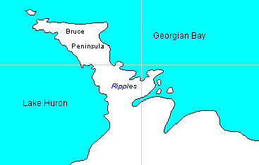 The map of Ontario's
Bruce Peninsula at left shows the location of linear
ridges of bedrock, identifed here as "giant current ripples", with
strike direction NW - SE, that are associated with a small group of
long, narrow drumlins near Sky Lake, in the central Bruce Peninsula.
The drumlins are oriented NE - SW, and the trend of the linear ridges
is normal to the axis of the drumlins. The available data from
wells drilled in the area shows these drumlins consist of bedrock
cores, some with a thin veneer of drift gravel, but the depth to
bedrock is variable. One of the drumlins in the area was the site of a
gravel pit. Both drumlins and "ripples" can be easily identified on
1:50,000 topographic maps and on air photos of the region.
The map of Ontario's
Bruce Peninsula at left shows the location of linear
ridges of bedrock, identifed here as "giant current ripples", with
strike direction NW - SE, that are associated with a small group of
long, narrow drumlins near Sky Lake, in the central Bruce Peninsula.
The drumlins are oriented NE - SW, and the trend of the linear ridges
is normal to the axis of the drumlins. The available data from
wells drilled in the area shows these drumlins consist of bedrock
cores, some with a thin veneer of drift gravel, but the depth to
bedrock is variable. One of the drumlins in the area was the site of a
gravel pit. Both drumlins and "ripples" can be easily identified on
1:50,000 topographic maps and on air photos of the region. 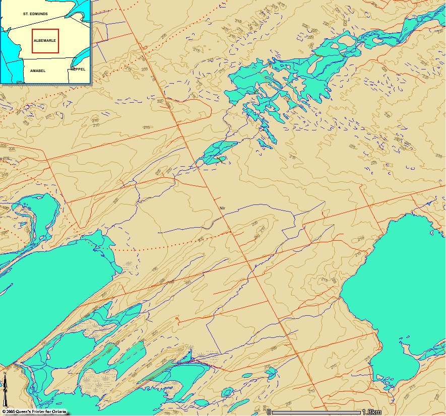
Map of the area where these linear ridges occur, located a few
miles north of the town of Wiarton. In the upper right of the image,
linear ridges north of Berford Lake, and east of Highway 6, are
indicated by the wavy contour lines, that show patterns of ridges
aligned NW-SE. In the lower left of the image, west of Highway 6, and
crossed by the Red Bay road, contours outline several long, narrow
drumlins that are
oriented normal to the patterns of bedrock "ripples." The map is
courtesy of the Ontario Ministry of Northern Development and Mines CLAIMaps.
 Click on this image for an aerial
photograph
of a group
of linear ridges crossed by Highway 6 [About 90 kbytes]. These bedrock
ridges, which appear
somewhat
lighter or remain as wooded areas, have the same orientation as the
ones in the
map image. Patterns of linear ridges with orientation NW - SE are
widespread on the Bruce Peninsula between Highway 6 and Georgian Bay.
Click on this image for an aerial
photograph
of a group
of linear ridges crossed by Highway 6 [About 90 kbytes]. These bedrock
ridges, which appear
somewhat
lighter or remain as wooded areas, have the same orientation as the
ones in the
map image. Patterns of linear ridges with orientation NW - SE are
widespread on the Bruce Peninsula between Highway 6 and Georgian Bay.| Try
the new satellite imaging service from Google
to view the patterns of drumlins and the ripples that occur upstream. Drag the image down and to the left to show up the linear patterns of ridges and troughs normal to the orientation of the drumlins. |
In conventional geologic theory, these linear ridges of bedrock (or giant current ripples) are indentified as exhumed "bioherms", or reef-like structures of biologic origin, but geologic maps clearly show the patterns of ridges transect two different geologic formations, the Amabel and Guelph formations, suggesting they are erosional features. The Amabel and Guelph formations both consist of dolostone. The Amabel formation forms the steep cliffs of the Niagara Escarpment in the Bruce Peninsula.
The bioherm interpretation of the patterns of linear bedrock ridges, although no doubt ingeneous, does not really explain their formation. It does not account for patterns of linear ridges resembling giant current ripples, or their orientation normal to drumlins that supposedly formed hundreds of millions of years later. Besides, there are problems when one attempts to explain how such ancient bioherms could have been exhumed, either by the hypothetical ice sheets, or by solution or weathering mechanisms acting over a vast time period.
Click here to read a post discussing the bioherm interpretation.
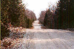 The photo
at right is a view along a road crossing the area of the giant
current ripples of bedrock. In the vicinity, the bedrock which forms
these
ridges was examined to determine whether patterns resembling cross
stratification
were present on the weathered vertical surfaces on the walls of
fissures.
If these are ancient bioherms, as has been claimed, such patterns of
cross
stratification would not be expected. Armstrong reported: "These
bioherms
lack the cross-bedding that would characterize any true giant current
ripples.
They contain simple lensoidal bedding that is uncharacteristic of any
ripple,
dune, or such features." (Armstrong 1993). Armstrong's failure to find
such evidence is inconcusive. My own investigation indicated the rock
in
the area of the giant current ripples shows the same characteristic
small
scale patterns resembling cross stratification etched into weathered
exposures
as other exposures of bedrock in the Bruce Peninsula.
The photo
at right is a view along a road crossing the area of the giant
current ripples of bedrock. In the vicinity, the bedrock which forms
these
ridges was examined to determine whether patterns resembling cross
stratification
were present on the weathered vertical surfaces on the walls of
fissures.
If these are ancient bioherms, as has been claimed, such patterns of
cross
stratification would not be expected. Armstrong reported: "These
bioherms
lack the cross-bedding that would characterize any true giant current
ripples.
They contain simple lensoidal bedding that is uncharacteristic of any
ripple,
dune, or such features." (Armstrong 1993). Armstrong's failure to find
such evidence is inconcusive. My own investigation indicated the rock
in
the area of the giant current ripples shows the same characteristic
small
scale patterns resembling cross stratification etched into weathered
exposures
as other exposures of bedrock in the Bruce Peninsula.
The limestones and dolostones of the Bruce Peninsula may have formed from reef derived materials, as the fossils present seem to indicate, but a more satisfactory interpretation of the linear ridges of bedrock is possible. An interpretation of these ridges as giant current ripples is consistent with the origin of drumlins by streamlining of partially unconsolidated sediment or rock by current action, followed by the process of disintegration. This concept was published as an appendix to my 1979 article, Drumlins and Diluvial Currents. It was proposed that the patterns of linear ridges in the Bruce Peninsula were eroded in partially unconsolidated carbonate sediments by transverse vortices which were developed in the currents that eroded drumlins a little downstream. The drumlins would represent the streamlining effects of longitudinal vortices in the currents. The currents were probably generated by differential crustal uplift centered in the Canadian Shield, northeast of Georgian Bay, that spilled the overlying waters to the southwest over the Bruce Peninsula. Only an environment of catastrophic erosion associated with crustal warping on a vast scale can explain all the deep lake basins associated with the Michigan Basin and the oriented erosional features, such as the various "re-entrant valleys" in the Niagara Escarpment, and drumlin fields. Crustal warping is also indicated by non-horizontal raised shorelines in the Great Lakes area.
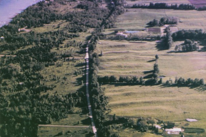 The
image at right is an aerial photo of some linear ridges along the
eastern
shore of Owen Sound, which appear to be a possible series of giant
current
ripples aligned normal to the axis of Owen Sound, one of the major
re-entrant
valleys in the Niagara Escarpment. If so, these features would be a
further
indication the erosion of the re-entrant valleys was caused by the fast
currents of displaced flood waters generated by crustal uplift centered
in the Canadian Shield east of Georgian Bay. Patterns of giant current
ripples such as these are not consistent with the action of
hypothetical
former ice sheets.
The
image at right is an aerial photo of some linear ridges along the
eastern
shore of Owen Sound, which appear to be a possible series of giant
current
ripples aligned normal to the axis of Owen Sound, one of the major
re-entrant
valleys in the Niagara Escarpment. If so, these features would be a
further
indication the erosion of the re-entrant valleys was caused by the fast
currents of displaced flood waters generated by crustal uplift centered
in the Canadian Shield east of Georgian Bay. Patterns of giant current
ripples such as these are not consistent with the action of
hypothetical
former ice sheets. See Also:
- Directional Erosion Evidence in Lake Huron
- Transverse drift ridges - giant current ripples?
- The Great Lakes and the Flood
References
Armstrong, D. K. (1993) Paleozoic Geology of the Central Bruce Peninsula. Ontario Geological Survey Open File Report 5856, Ontario Ministry of Northern Development and Mines, Toronto, Ontario.Armstrong, D. K. (1993) Paleozoic Geology of the Central Bruce Peninsula. Ontario Geological Survey Preliminary Map P. 3191, Scale:1:50,000. Ontario Ministry of Northern Development and Mines, Toronto, Ontario.
Armstrong, D. K., and J. R. Meadows (1990) Stratigraphy and Depositional Environments of Niagaran Carbonates, Bruce Pennisula, Ontario. American association of Petroleum Geologists Eastern Section 1990 Annual Meeting Field Trip No. 2, London, Ontario. Ontario Petroleum Institute, London, Ontario. 59 pp.
Cox, D. E., 1979. Drumlins and Diluvial Currents. Creation Research Society Quarterly, Volume 16(3):154-162.
Smith, A. L., and J. A. Legault (1985) Preferred orientation of Middle Silurian Guelph-Amabel reefs of southern Ontario. Bulletin of Canadian Petroleum Geology, vol. 33, pp. 421-426.
Related Links
The Niagara Escarpment -- An Earth Chronicles EpisodeA picture of some giant current ripples in Montana
Copyright © 1997-2005 by Douglas E. Cox
The Creation Concept | Controversy
About the Glacial Theory