The image is from the Shaded Relief Image of Gridded Data in
and around
Lake Ontario,
http://www.ngdc.noaa.gov/mgg/greatlakes/greatlakes.html
View
image source (1.9 mb)
|
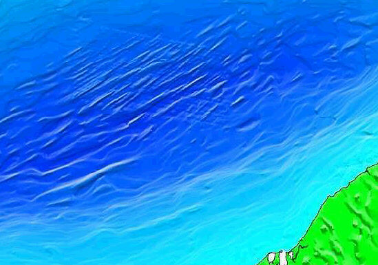
| Part of a Digital Elevation Model image showing
streamlined
features on the bottom of Lake Ontario, in the Rochester Basin at the
eastern
part of the lake. The NY shoreline is at the bottom right. The parallel
ridges are similar in form to drumlins north of the lake, e.g. the
drumlins
in the Peterborough drumlin field. They are evidence for erosion by
catastrophic
currents generated by crustal uplifts when the land was
submerged.
The image is from the Shaded Relief Image of Gridded Data in
and around
Lake Ontario, |
The orientation of the drumlins on the floor of Lake Ontario indicates the current flowed from northeast to southwest when they were formed. The drumlins in the above image resemble those in drumlin fields north of the lake (Lewis et al, 1997), in the area of Peterborough, Ontario. Relief is 15-25 m. and spacing between drumlins is 250-1000 m. They occur occur at the deepest part of the floor of Lake Ontario, about 250 m. below lake level.
The form of drumlins indicates they were formed by fast current flow. Drumlins were shown to be caused by currents of a great flood rather than ice-sheets in the writer's 1979 article Drumlins and Diluvial Currents. Also in 1979, the writer discussed the ideas of some early American geologists about the cause of the Great Lakes, in Controversy about Ice Ages. The early investigators observed the tilted sedimentary formations around the Great Lakes and concluded that immense quantities of rock had been removed. The Niagara Escarpment, for example, is a remnant of a sedimentary formation that once extended out over the basin where Lake Ontario is now found. Due to some immense erosional action, the strata are now missing.
George F. Hayes of Buffalo wrote:
There can be no doubt that the rock strata in the western part of New York, have been disintegrated and removed, from extensive tracts north of their present limits. It would be absurd to suppose they were once deposited in such ridges, with steep escarpments, as we now find them ... That these rocks were deposited at the bottom of an ocean, is evinced by their fossil contents; that they have been elevated from its watery bed, requires no additional evidence other than their present altitude above its permanent level. If we seek for the cause of this gigantic phenomenon, and trace the ascending strata in a direction opposite their dip, we invariably come to primitive rocks.
The inference is that differential uplift of the basement caused the tilt of the sedimentary rocks. Erosion of the basins of the lower Great Lakes, along with hundreds of other lakes in the Canadian Shield, can be attributed to the currents generated as water was displaced when the submerged land was uplifted. The Great Lakes basins, the Niagara Escarpment, and the Finger Lakes of New York, may all owe their origin to the erosional action of these currents. Along with erosion, the writer outlined a mechanism for the in situ disintegration of rocks, that accompanied unloading as sediment was removed, which enhanced the erosion. This in situ disintegration formed the mantle of drift.
Beginning in 1983, a series of articles by J. Shaw and co-workers invoked catastrophic subglacial meltwater floods to explain drumlin formation. Shaw and Gilbert proposed erosion of the basin of Lake Ontario by subglacial meltwater currents driven by hydraulic pressure in Shaw and Gilbert (1990). This seems less competent to explain the effects than currents generated by crustal movements when the land was submerged. The glacial meltwater hypothesis seems incapable of providing the volumes of water needed, or currents having sufficient power to account for the extent of erosion required for excavating the Great Lakes basins.
Sir J.W. Dawson wrote in 1891:
Our American lake-basins are cut out deeply into the softer strata. Running water on the land would not have done this, for it could have no outlet; nor could this result be effected by breakers. Glaciers could not have effected it; for even if the climatal conditions for these were admitted, there is no height of land to give them momentum. But if we suppose the land submerged so that the Arctic current, flowing from the north-east, should pour over the Laurentian rocks on the north side of Lake Superior and Lake Huron, it would necessarily cut out of the softer Silurian strata just such basins, drifting their materials to the south-west. At the same time, the lower strata of the current would be powerfully determined through the strait between the Adirondac and Laurentide Hills, and, flowing over the ridge of hard rock which connects them at the Thousand Islands, would cut out the long basin of Lake Ontario, heaping up at the same time, in the lee of the Lawrentian ridge, the great mass of boulder clay which intervenes between Lake Ontario and Georgian Bay. Lake Erie may have been cut by the flow of the upper layers of water over the Middle Silurian escarpment; and Lake Michigan, though less closely connected with the direction of the current, is, like the others, due to the action of a continuous eroding force on rocks of unequal hardness.
Dawson supposed the Arctic currents transported ice-floes with embedded boulders, that he suggested caused striations on the streamlined rock surfaces, but the currents required for excavating the basins of the Great Lakes must have been much more powerful than those Dawson proposed, and were capable of transporting a bedload of gravel and boulders, which striated and polished rocks as they swept over them. Drumlins were formed as the currents shaped the bed into forms that minimized turbulence. The erosion of lake basins was aided by in situ disintegration that accompanied the removal of overburden. As fresh rock was exposed to lower pressure, disintegration occurred, changing rock to unconsolidated sand, gravel and clay, that was easily removed by the fast currents.Currents that streamlined bedrock, forming drumlins, and excavated the basin of Lake Ontario also eroded the basin of Lake Erie, carving out a 40-60 m deep scour off Long Point. These and other geomorphic features point to powerful currents generated by uplifts when the land was submerged, that swept over the Great Lakes region, forming drumlin fields having various orientations, and excavating lake basins.
Dawson, Sir J.W.1891. Acadian Geology, 4th Edition. MacMillan & Co., London, 1891, pp. 66-73.
Lewis, C. F. M., L. A. Mayer, G. D. Cameron, and B. J. Todd, 1997, Drumlins in Lake Ontario, in T. Davies, et al., (eds.), Glaciated Continental Margins: an Atlas of Acoustic Images, Chapman and Hall, London, p. 48-49.
Shaw, J., and R. Gilbert, 1990, Evidence for Large-Scale Subglacial Meltwater Flood Events in Southern Ontario and Northern New York State, Geology, v. 18, p.1169-1172.
© Copyright 2003, 2006 by Douglas E. Cox
All Rights Reserved.
The Creation Concept