On the Summit of Silver Peak

On the Summit of Silver Peak |
|
|
|
|
| Streamlined quartzite near
the summit of Silver Peak, in Killarney Provincial Park, Ontario. |

|
|
| The photo shows details of the
streamlined quartzite near the summit of Silver Peak, about 360 m above
the water level of Georgian Bay. The features resemble streamlined rocks
that occur along the shore of Georgian Bay. Note that striations
are parallel to the streamlining. |
Streamlining in granite |
|

|
|
| Streamlined rocks in Killarney
Provincial Park, seen from the turn-off road to Bell Lake. Undercut channels
carved in steep rock faces are called cavettos, and are attributed
to vortices that impinged on the rock in the streamlining environment. Current
flow was towards the southwest, left in the photo. |

|
|
| Streamlined granite rocks along
the shore of Georgian Bay, at the Western Entrance of Collins Inlet. |
Erratic boulder transported by currents |
|

|
|
| The photo shows a boulder of quartzite
on granite bedrock at the location from which the previous photo was
taken, the Western Entrance to Collins Inlet near the shore of Georgian
Bay. In this area, most of the boulders and pebbles smaller than 0.3 m
have been swept away by the powerful currents that caused streamlining of
granite and quartzite. This boulder appears to have been transported by
the currents from the La Cloche Mountains several km northeast of the site. |
|
|
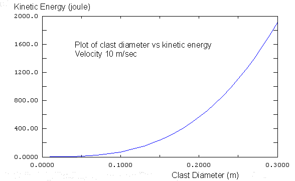
| Variation of kinetic energy with clast
diameter for clasts with velocity 10 m/sec. The estimated velocity of currents
in the cataclysmic floods at the nearby French River was between 4 and
15 m/sec, according to Kor et al (p. 640). In contrast, the kinetic energy
of clasts at the base of an ice sheet would be negligible because of the
extreme slowness of ice motion. Reference: Kor, P.S.G., Shaw, J., and Sharpe, D.R., 1991. Erosion of bedrock by subglacial meltwater, Georgian Bay, Ontario: a regional view. Canadian Journal of Earth Sciences, 28: 623-642. |
Cycle of uplift, erosion, disintegration |

|
| The graphic above illustrates the cycle of uplift during former catastrophic conditions. Uplift of submerged areas generated fast currents, which caused erosion, and removed sedimentary overburden. Streamlining of rocks is evidence of erosion by those fast currrents. Unloading initiated disintegration, and formation of drift, which may have promoted more erosion, as disintegrated materials were more easily eroded. Currents transported the sediments far from the eroded areas and redeposited them. The isostatic consequences of enhanced erosion completed the cycle, resulting in further uplift. This cycle of uplift, erosion, and disintegration could result in rock basins, such as those occupied by the Great Lakes. |