The occurrence of
these large bedrock masses amid the Pleistocene drift is disconcerting.
- A. MacS Stalker |
The large chalk rafts are presumed to have been
transported frozen to the basal ice from the sea floor of the Baltic,
at least 25 km northwards to Kvarnby. Larger rafts were probably
divided into smaller ones during the deposition. This would imply that
the ground was frozen to a depth of at least 30 m before the rafts were
torn away from the bedrock in the Baltic. |
Stick-Slip Mechanism of Basal Ice In the southern Sperrin Mountains subglacial sediment sequences comprise tabular bedrock rafts which are interbedded with diamicton (till) and brecciated bedrock and separated by glaciotectonic shears. Bedrock rafts and diamicton beds alternate laterally and vertically in the sediment profile, suggesting that the ice-bed interface was chequered spatially with both high-strength (rock rafts) and low-strength (diamicton) patches during accumulation of the sediment pile. |
The northern Great Plains is one of the world's
premier regions for glaciotectonic structures and landforms. All
manner of composite ridges, hill-hole pairs, and megablocks are found
from
North Dakota to central Alberta. Several factors contributed to
widespread glaciotectonism: ice advance upslope against topographic
barriers, poorly consolidated bedrock containing confined aquifers,
proglacial lakes, and surging activity of ice lobes (Aber et al. 1995). Exceptionally large ice-pushed ridges are developed along the Missouri Coteau of southern Saskatchewan and eastern Alberta--see Fig. 16-5. The Dirt Hills and Cactus Hills are among the best developed ice-pushed ridges in the world (Aber 1993a). They are located on the Missouri Coteau upland southwest of Regina in southern Saskatchewan. The highest elevations of the Dirt Hills exceed 2880 feet (880 m), more than 1000 feet (300 m) above the Regina Lake Plain immediately to the north, and 400 feet (120 m) above the Missouri Coteau upland to the south. |
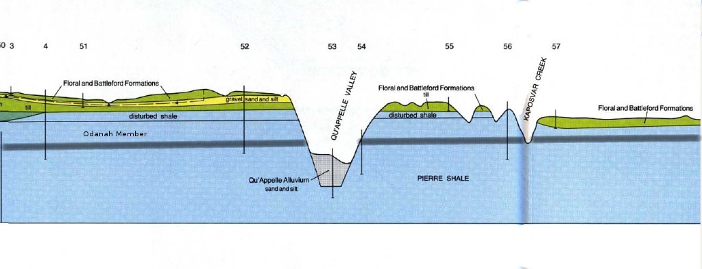
The only conceivable means of displacing a megablock of such size was by freezing onto the bottom of an overriding ice sheet, in which case the megablock became the basal layer of the ice sheet. It is highly improbable, given its dimensions, that this megablock could have been pushed in front of an advancing glacier, whether it was permafrozen or not. Subglacial sliding of a permafrozen slab over a thawed substratum seems to be the most likely explanation for displacement of the Esterhazy megablock. |
![]() This map shows the Esterhazy megablock, composed of the Odanah Member of the Pierre Shale, in gray. The Odanah Member is a hard, siliceous, light-gray shale. A layer of Pierre Shale overlies the Odanah Member in the western part of the southern section of the megablock. The Pierre Shale (formerly known as the Riding Mountain Formation) in the area is a thick, soft, gray noncalcareous silt and clay, that has not been consolidated into solid rock, with the exception of the Odanah Member. The map was prepared by the writer from the Geological Atlas of Saskatchewan. The towns of Esterhazy and Rocanville are shown, along with roads and rivers. The border of Saskatchewan and Manitoba is the edge of the green on the right side of the map. The other lines represent drumlins or flutings on the drift surface. |
Composite Ridges and Thrust Block Moraines · The Dirt Hills and Cactus Hills, Missouri Coteau uplands, southern Saskatchewan, Canada. · Dirt Hills and Cactus Hills are large composite ridges formed by the advancing of ice lobes from the Laurentide ice sheet which folded and thrusted the bedrock. · The hills rise up to 150 metres above the Missouri Coteau and cover and area of approximately 1000 km2. · The ridges are arcuate in shape and are parallel to each other with narrow valleys in between. · The ridges are made of folded Upper Cretaceous bedrock. A layer of glacial sediment covers most of the ridges, except in the southern Dirt Hills. |
The Oldman Valley, at Lethbridge, contains a
number of quite visible glacial landforms. None, are perhaps more
visible then those of mega blocks. Look (click)
on the picture above, can you see the light grey slab of sandstone
bedrock, sandwiched between the tills? This particular landform is
called the Laundry Hill mega block. Mega blocks, are an unusual
feature. The Laundry Hill mega block, was sandstone, from the exposed
Oldman Formation northwest of the city and transported south to this
location by glaciers. It was
then dislodged as the glacier approached the valley.
Geomorpholigists, such as Renee Barendregt, suggest that the mega block
on Laundry Hill, may have been 1 square kilometer in size. Mega
blocks are essentially formed when glaciers are able to dig large slabs
of bedrock, and transport them to new locations. |
These deposits are remarkable for the
substantial quantity of Cretaceous bedrock contained as immense blocks
in them,
and for the presence of other sediments containing small amounts of
organic matter. The large masses of Cretaceous bedrock are a puzzling
feature
of these intertill deposits, and their presence is as yet completely
unexplained. The mention of these bedrock blocks solely in the
descriptions of Sections 1 and 3 does not do justice to their
widespread occurrence. They are present also in exposures near Section
2, and in practically every exposure along Oldman River between
Section 3 and the junction of the Bow River, a distance of about 100
miles (about 60 miles in a straight line). In some places a continuous
block of this intertill bedrock is more than a
mile ling, and in some instances may possibly extend continuously for
several
miles. In addition there is indication from drill-hole logs that one of
these
large masses 8 to 10 miles north-northeast of Taber may be spread over
several
square miles and be up to 90 feet thick, though generally much thinner.
Commonly, and perhaps in most exposures, the bedding in these masses is
approximately horizontal or only slightly deformed, but elsewhere there
is much contortion. The large bedrock masses are thought to be in
equivalent stratigraphic positions in all exposures, and thus they form
an extremely valuable
and easily recognized marker horizon. The occurrence of these large bedrock masses amid the Pleistocene drift is disconcerting. Slumping takes place with great ease in the soft, easily lubricated bedrock of the area,, but this is not thought to be the cause of their displacement. Slumping should cause more contortion and deformation of the beds than is found, and such extensive but relatively thin blocks would hardly be expected to hold together under such a method of transportation. The chief argument against slumping as then agent of transportation is the apparent lack of proper conditions of gradient necessary to cause such slumping. Shove or pushing by an ice-sheet also seemingly would not allow such widespread thin blocks to retain their shape or even hold together during movement. The most attractive hypothesis, even though not satisfactory, is that these masses were dragged beneath an actively moving glacier into their present positions. The top of the bedrock may have become attached to the base of the ice-sheet by freezing, pulled away from the underlying bedrock, and then slid over the underlying slippery shales and tills to be deposited when the glacier could drag it no farther. A high water-table, such as would likely be present under glacial conditions, could have aided the process by increasing the lubrication of the underlying deposits. There remains the fact, however, that in many places are overlain by alluvium (e.g., Section 3), whereas if they had been dragged into place beneath the ice, they would presumably be overlain by till. The question as to their means of transportation cannot yet be answered. |
Aber, J.S. 1989. Spectrum of constructional
glaciotectonic landforms. In: Goldthwait, R.P. and Matsch, C.L.,
Eds. Genetic Classification of Glacigenic Deposits: Final Report
of the Commission on Genesis and Lithology of Glacial Quaternary
Deposits of the International Union for Quaternary Research
(INQUA). A.A.Balkema, Rotterdam. pp. 281-292. Aber, James S., Croot, David S., and Fenton, Mark M., 1989. Glaciotectonic Landforms and Structures. Kluwer Academic Publishers, Dordrecht. Aber, J.S., Bluemle, J.P., Brigham-Grette, J., Dredge, L.A., Sauchyn, D.J. and Ackerman, D.L. 1995. Glaciotectonic map of North America, 1:6,500,000. Geological Society of America, Maps and Charts Series, MCH079. Benn, D.I. and Evans, D.J.A. 1998. Glaciers and Glaciation. Arnold. Boulton, G.S., 1986. Push-moraines and glacier-contact fans in marine and terrestrial environments, Sedimentology, p677-698. Clayton, L., Teller, J.T. and Attig, J.W. 1985. Surging of the southwestern part of the Laurentide Ice Sheet. Boreas 14: 235-241. Ehlers, J, ed. 1983. Glacial Deposits of North-West Europe. A.A. Balkema. Rotterdam. Knight, J., 2001. Field Geological Evidence Supporting a Stick-Slip Mechanism of Basal ice Flow From a Late Pleistocene Ice Sheet. AGU 2001 Fall Meeting. http://www.agu.org/meetings/fm01/fm01-pdf Kupsch, W.O. 1962. Ice-thrust ridges in western Canada. Journal of Geology 70:582-594. Ringberg, B. 1983. Till stratigraphy and glacial rafts of chalk at Kvarnby, southern Sweden. In: Ehlers, J. Op.Cit. p. 151-154. Saskatchewan Soil Survey, 1987. The soils of the Moosomin, Martin, Rocanville and Spy Hill Rural Municipalities Nos. 121,122,151,152 Canada National Land and Water Information Service, SKS207. http://sis.agr.gc.ca/cansis/publications/sk/sks207/intro.html Stalker, A. MacS. 1963. Quaternary stratigraphy in Southern Alberta. Geological Survey of Canada, Paper 62-34. USGS, 2000. Quaternary Geologic Atlas of the United States, Winnipeg 4° x 6° Quadrangle, U.S. and Canada, Miscellaneous Investigations Series, Map I-1420 (NM-14). http://pubs.usgs.gov/imap/i-1420/nm-14/I-1420_nm-14_screen.pdf |