
View of the bluffs of drift near Port Stanley, Ontario. There were few areas where the proposed ice sheet could access the bedrock, to derive source materials for manufacturing the later drift, once the earliest drift layers were deposited. Since drift composition tends to resemble that of the local bedrock, the source cannot be some distant location. Access to source materials consisting of suitable rock types is required for the manufacture of the pebbles and boulders contained in coarse gravels in the glacial environment. But the materials that ice apparently over-rode were often unsuitable for producing these gravels. In many areas the ice must have over-rode silt, clay or sand, not dolomite or limestone bedrock. The bluffs at Port Stanley shown in the above photo illustrate this type of material. Boulders and pebbles of limestone and dolomite cannot be made from drift consisting of unconsolidated silt or clay. Access to suitable bedrock materials by the ice sheet would decline as more layers of drift were deposited.

 The
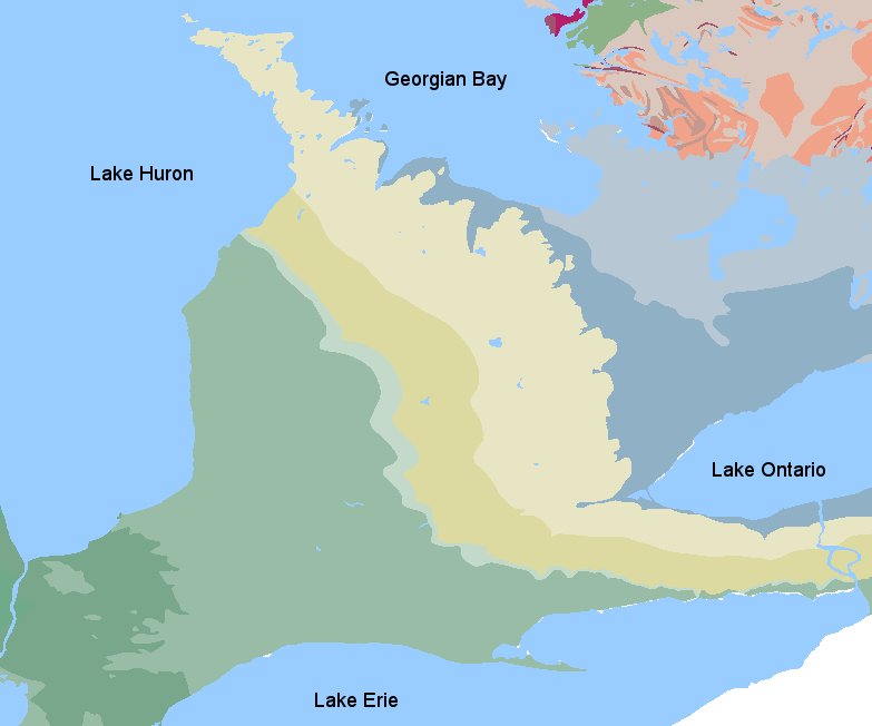
map at right, from the USGS Quaternary Geologic Map of the Lake
Erie area, shows ice
lobes from Lake Huron, Lake Erie, Georgian Bay, and Lake
Ontario flowing out of their basins, in various
directions. Even more complex flow patterns are proposed for ice lobes
of earlier periods. Note that the southern limit of the drift is
only a little way south of the eastern end of Lake Erie. The force that
caused the northward flow of the ice lobes out of lakes Erie and
Ontario is mysterious. Why would the ice have flowed both
northwest and southeast out of Lake Erie?
The
map at right, from the USGS Quaternary Geologic Map of the Lake
Erie area, shows ice
lobes from Lake Huron, Lake Erie, Georgian Bay, and Lake
Ontario flowing out of their basins, in various
directions. Even more complex flow patterns are proposed for ice lobes
of earlier periods. Note that the southern limit of the drift is
only a little way south of the eastern end of Lake Erie. The force that
caused the northward flow of the ice lobes out of lakes Erie and
Ontario is mysterious. Why would the ice have flowed both
northwest and southeast out of Lake Erie? The
effects of longitudinal vortices in currents are especially
evident north of Lake Ontario in the
drumlin field around Peterborough, where thousands of drumlins show the
streamlining
effect of the currents. The image at right is a Digital Elevation
Model (DEM) of part the drumlin field, in the area east of Peterborough
including the northern end of Rice Lake. Some drumlins are islands in
the lake. The current flow was toward the south.
The
effects of longitudinal vortices in currents are especially
evident north of Lake Ontario in the
drumlin field around Peterborough, where thousands of drumlins show the
streamlining
effect of the currents. The image at right is a Digital Elevation
Model (DEM) of part the drumlin field, in the area east of Peterborough
including the northern end of Rice Lake. Some drumlins are islands in
the lake. The current flow was toward the south.  Currents flowing towards the west-southwest,
generated by uplift in the submerged Shield, excavated
the basins of Lake Ontario and Lake Erie. Drumlins in the eastern basin of Lake Ontario record the trend of the current flow along the axis of the lake basin. Some of the
drumlins along the southern shore of the lake were cut in half by this
westerly current. Drumlins on the Niagara Peninsula indicate a westerly flow. A deep basin is present in the eastern part
of Lake Erie that was probably scoured by these currents.
Currents flowing towards the west-southwest,
generated by uplift in the submerged Shield, excavated
the basins of Lake Ontario and Lake Erie. Drumlins in the eastern basin of Lake Ontario record the trend of the current flow along the axis of the lake basin. Some of the
drumlins along the southern shore of the lake were cut in half by this
westerly current. Drumlins on the Niagara Peninsula indicate a westerly flow. A deep basin is present in the eastern part
of Lake Erie that was probably scoured by these currents. 