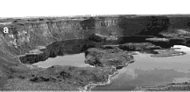
 |
| Dry Falls in the Washington Scablands
[Photo courtesy of John Shaw] |
This catastrophic flooding occurred only a few thousands of years ago. In the area there are streamlined hills, and giant current ripples formed by rapid currents. A few creationists have supposed that these landforms were due to the effects of currents of the Noachian flood. Perhaps the currents were generated by differential uplift of the earth's crust as the floodwaters retreated towards the ocean basins.
Conventional geologic theory says the features investigated by Bretz were formed by a series of catastrophic floods due to periodic bursting of hypothetical ice dams on the present Clark Fork river at Pend Oreille Lake. This theory makes a number of remarkable claims:
|
| Dry Falls in the Washington Scablands
[Photo courtesy of John Shaw] |
If there was no Ice Age, ice dams would not be a likely explanation for this evidence of catastrophic flooding. An alternative to the ice dam theory must be proposed. Perhaps the flooding in the Washington Scablands was due to the flood mentioned in Genesis. If so, the high level shorelines would indicate submergence of the land, and there has been crustal uplift on a vast scale.
The plausibility of former ice dams for causing the Lake Missoula floods is discredited in the following discussion by Charles Ginenthal.
According to geologists, the ice dam that formed the lake that flooded the Washington scablands did so about 16,000 years ago, while the Ice Age was still in full force. No volcanic regions north of the ice sheet, where the lake supposedly formed, are found there so as to heat the ice. There is evidence of a relic shoreline for the lake, but the oceanic water flowing under the ice could have lifted it to create a short-lived lake. In addition, the ice front facing south would always melt first.We are expected to believe that the area behind the ice dam, north of the ice front, melted to a depth greater than 2,000 feet and that the warmer ice front to the south did not melt. However, ice and snow melt gradually, from south to north, in springtime; exactly how the icecap would have melted at the end of the Ice Age. Such a large body of water would be a heat source to tunnel its way through or under the ice. Some of these giant lakes supposedly formed north of the midwestern states, where there are no mountains acting as barriers to the lake water. This is true with regard to the drumlins, elongated mounds of glacial material sorted by water action. Smaller ice dams, which generate floods, do exist.21 Of more importance, however, no geologists have explained the presence of whales in postglacial material, which contradicts the theory of freshwater, glacial dam flood formation.
Any long-lived, large, deep body of water in a glacier would melt a channel either under or through the ice and would flow away as a river. Such rivers are found in the icecaps of Greenland and Antarctica,22 and no such immense, deep glacial lakes have ever been seen in either region.
Scientists have invented an ad hoc process, for the creation of a lake, which contradicts climatic and geophysical thermal conditions. However, Warren C. Hunt exposed another problem related to such an ice dam. He claimed that it would be impossible for an ice dam to hold back a lake of water 2,100 feet deep.23
According to Hunt, since modern engineering employs bedrock grouting for securing the footings of 500-foot...dams, it must strike any reader as...frivolous to suggest that chance emplacement of glacial ice might have dammed Clark Fork across a 7-mile...span lacking in intermediate abutments and then retained water at four times the pressure of modern, engineered, concrete dams!24
In fact, Hunt proved the dam was emplaced elsewhere and "would have had an unsupported length of approximately 50 [miles]...."25
He said that "[i]ce has no effective tinsel strength"26 and would break under the stresses created by the pressure on an ice wall over seven miles in length. Consider picking up a block of ice measuring 100 feet long x 20 feet thick x 40 feet wide at its ends. The weight of the ice block will cause it to snap and break. The longer the length of the dam, the easier it is to break.
Mark L. Lord and Alan E. Kehew were able to show that, in plain regions where there are no mountains to impound water, [g]lacial-lake outburst floods were common in the northern Great Plains during the Pleistocene Epoch. Sedimentologic and paleohydraulic interpretations...support geomorphic evidence of large magnitude, highly competent discharges from glacial lake outbursts. Large-scale bars consisting of matrix-supported, poorly sorted, pebbly cobble gravel were deposited by hyperconcentrated flows, probably between 20% and 40% sediment by weight.27
According to their paleohydraulic calculations, between 60,000 and 900,000 cubic yards of water were discharged per second. Of course, they do not discuss having found whales in nearby regions. To admit this would destroy the ice dam-lake bursting concept.
On the Bruce Peninsula in Ontario, a few miles north of Wiarton, there are patterns of giant current ripples, oriented normal to the axes of nearby drumlins, that occur in hard limestone bedrock. These giant ripples seem to have similar form and scale to those of the Columbia Valley in the Washington Scablands. The evidence here suggests there was catastrophic erosion due to spilling of floodwaters to the southwest, the currents being generated by rapid crustal uplift centered somewhere in the Canadian Shield northeast of Georgian Bay. The tectonic movement as the land was elevated at the end of the flood apparently spilled flood waters towards the southwest over the Bruce Peninsula, and similar catastrophic events and tectonically generated currents probably excavated each one of the Great Lakes, the Finger Lakes of New York, and many other rock basins that have become lakes.
The idea of former ice sheets in the area seems to be disproved by the unstable structure of pinnacles and stacks that occur at several locations along the Niagara Escarpment. The Flowerpots at Flowerpot Island are the best known of these, but other unstable pinnacles occur at several locations along the escarpment in Ontario. The Flowerpots occur in locations that would obviously have received the maximum wear and tear from any former glacier in the area of Georgian Bay that swept over the escarpment, and they seem inconsitent with the idea of glaciation.
The Niagara Escarpment itself has many features characteristic of "driftless areas" such as that of southwest Wisconsin and Illinois where no former glaciation could have occurred.
At Rockwood, near Guelph, Ontario, there are crags and pinnacles of rock, features that suggest this is another small "driftless" area. Glacialist A.P. Coleman, in one of his books on the ice age, showed an illustration of one of these crags at Rockwood and correctly stated it was "unglaciated" in the caption. Yet, the area lies in close proximity to some large bedrock drumlins. These apparently were formed by current flow from the southeast, an orientation which seems quite anomalous in any glacial interpretation. What could have driven the hypothetical ice uphill, over the steep cliffs of the Niagara Escarpment, towards the northwest, out of the deep basin of Lake Ontario? And how could ice have flowed towards the south at the same time, and form the Finger Lakes, and the thousands of drumlins in New York? Clearly the glacial theory is in big trouble here.
Elevated ancient shorelines in the areas around the Great Lakes indicate extensive crustal movements were involved in the generation of currents that formed the drumlins, as the crustal warping and tilting revealed by ancient shorelines, which are not horizontal, corresponds with the direction of flow indicated by the streamlined landforms and eroded features. That is, where the shorelines are higher, the land was raised and the tectonic movements spilled the overlying floodwater elsewhere, and generated the currents that streamlined the land into drumlins, and eroded lake basins.
The patterns of drumlins correspond with the tilting indicated by the shorelines, and also with the structure, or dip, of the rock strata in the area known as the Michigan Basin. Ancient shorelines and drumlins composed of drift gravels and sand would be easily eroded away over a very long period. These features must have all formed only a few thousands of years ago, and the major erosion events may quite reasonably be associated with the great flood mentioned in Genesis, or the tectonic adjustments that followed it.