Great Lakes Origin by Diastrophic Processes
Escarpments a Barrier to Ice
 The
Niagara Escarpment, shown at Lion's Head, along the eastern shore of the
Bruce Peninsula in Ontario in the photo at right, is a line of resistant
cliffs composed of dolomites and limestones of the Niagara Formation. It
forms a cuesta around the Michigan Basin.
The
Niagara Escarpment, shown at Lion's Head, along the eastern shore of the
Bruce Peninsula in Ontario in the photo at right, is a line of resistant
cliffs composed of dolomites and limestones of the Niagara Formation. It
forms a cuesta around the Michigan Basin.
Near the escarpment, directional indicators such as drumlins and aligned
valleys show the former current flowed towards the major sedimentary basins
and away from the Canadian Shield, and flow was from the lower side of
the escarpment to the higher. South of Lake Ontario, the escarpment runs
east-west and has a similar relation to the Allegheny Basin. Drumlins in
New York are also aligned normal to the trend of the escarpment. These
facts indicate no former ice sheet could have been involved in its
formation. The escarpment would have presented a barrier to the motion
of former ice sheets, as the proposed ice flow would have to be up and
over the line of steep cliffs.
In Lake Huron, another submerged escarpment stretches from Clark Point,
Ontario, to North Point, Michigan. It slopes away steeply to below sea
level on the north. This escarpment also would present a barrier to the
flow of any hypothetical former ice sheet eroding the basin of Lake Huron.
The escarpments in the Great Lakes region indicate that large scale,
catastrophic currents were a necessary cause for the excavation of the
lakes, when the region was submerged, and the crust was actively warping
and generating currents. The trends of drumlin fields suggest the cause
of the currents was the differential uplift that caused the dip in the
sedimentary rocks, and formed the sedimentary basins and uplifted the shield
areas. The excavation of the lakes was aided by the in situ disintegration
of bedrock surfaces, forming drift sand and gravel, as the overburden was
being removed by the currents.
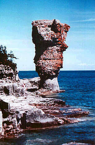
Flowerpot Island
On Flowerpot Island, north of the Bruce Peninsula, there are two unstable
stacks or pillars of fractured rock, standing on the eastern shore, a location
which would have received maximum wear and tear from the supposed movement
of a hypothetical ice sheet flowing over the region. Presumably, the ice
would have to sweep up and over the escarpment from the depths of Georgian
Bay, leaving these rock pinnacles intact! The presence of these stacks
seems to discredit the idea of former ice sheets in the region of Georgian
Bay. |
 |
A.P. Coleman noted evidence within the Great Lakes discrediting idea
that ice sheets could have scoured the region. He wrote [Coleman 1941,
p. 123]:
In 1901, I rowed a clumsy fishing boat seven miles out from
the north shore of Lake Superior to the Slate Islands and found no drift
on them, only deeply weathered gneiss, above which stood walls and pinnacles
of dike rocks; and in my notes there is a suggestion that the islands must
have been nunataks. A. L. Parsons, who visited them later, got the same
impression, and mentions also deep weathering of rocks a hundred miles
south-east in the Michipicoten mining district.
On the north shore of Lake Huron, too, Collins has noted dikes which
stand up as walls 10 feet above weathered quartzite; and on Bruce Peninsula
between Lake Huron and Georgian Bay the tableland rising 400 to 1,000 feet
above the water shows only Precambnan boulders and a greatly weathered
surface of Niagara limestone, while at low levels there is fresh boulder
clay with beautifully polished and striated limestone pebbles, indicating
that the Wisconsin ice lobe was thin and failed to sweep over the highland.
Reference
A.P. Coleman, 1941. The Last Million Years, U.
of Toronto Press.
© 1999 by Douglas E. Cox
The Creation Concept