Catastrophic Flood Dynamic Database
Western Canada
Canadian geologist G.M. Dawson thought that the whole western region of
Canada had been below the sea, and was widely flooded with salt or brackish
water [Coleman, 1941, p. 172.]. Dawson's
biographer wrote [Winslow-Spragge, 1962
p. 113]:
With regard to the glaciation of the northern part of
the Great Plains, Dr. G.D. maintains that the region, as a whole,
has been submerged, and that floating ice has been the main agent in its
glaciation, a view which is not in accord with that of the majority
of American geologists.
Dawsons conclusion was likely based on the distribution of silt sediments
and elevated shorelines, later interpreted as beaches of ice dammed lakes,
especially Glacial Lake Agassiz, by W. Upham.
 Some
of the most impressive evidence for large scale catastrophic flooding is
the streamlined drumlin field located in the Livingstone Lake area of northwestern
Saskatchewan, that was described by Shaw and Kvill [1984].
Shaw and Kvill proposed a mechanism for flooding involving subglacial melt
water that accumulated beneath a hypothetical ice sheet.
Some
of the most impressive evidence for large scale catastrophic flooding is
the streamlined drumlin field located in the Livingstone Lake area of northwestern
Saskatchewan, that was described by Shaw and Kvill [1984].
Shaw and Kvill proposed a mechanism for flooding involving subglacial melt
water that accumulated beneath a hypothetical ice sheet.
According to their theory, the pressurized subglacial water suddenly
burst out, releasing a powerful flood, driven by the pressure of the overlying
ice sheet. The currents eroded and streamlined the rocks and drift beneath
the ice, forming drumlins and other features over wide areas. Their proposed
mechanism has since been applied in several other areas, including the
Avalon Peninsula of Newfoundland; the northeastern shore of Georgian Bay,
Ontario; the basins of Lake Ontario and Lake Erie; the drumlin fields of
northwestern New York; Lake Michigan, and the interior of British Columbia
where subglacial meltwater is believed to have contributed to the great
Lake Missoula flood in Eastern Washington, first described by J.H. Bretz.
An objection sometimes raised against the glacier meltwater flood theory
is that the volume of water that could accumulate beneath the hypothetical
ice sheet would be inadequate for floods with the immense volumes estimated
by Shaw and his coworkers.
The alternative to the subglacial meltwater flood
theory, that is supported by the writer, does not have this limitation,
and does not require an ice sheet "lid". Instead, currents were initiated
by tectonic uplift of submerged lands. Streamlined landforms indicate the
course of the currents generated by the uplifts, so we can infer the general
source areas. Crustal uplifts in the northern part of the Canadian Shield
probably generated the currents that formed the Livingstone Lake area drumlins.
Where differential uplifts involved very large areas, the volume of
the floods that flowed over areas peripheral to the uplifted areas could
be very large, because current velocity over any part of the perimeter
would depend upon the volume (square of the radius times depth), while
the length of the perimeter depends on the radius. If currents had been
restricted due to land rising above the surface, the current velocity in
those confined areas would be increased.
Currents flowed from the Shield towards the southwest over the Livingstone
Lake area, and were diverted towards the north and south at the foothills
of the Rocky Mountains. Evidence of these catastrophic current flows is
found in various parts of the province of Alberta. For example, Munro and
Shaw proposed that subglacial meltwaters caused a flood that formed streamlined
hills and transverse ridges (rogen
moraine), hummocky terrain, etc., in south-central Alberta. [Munro
and Shaw 1997]
Alberta's giant current ripples
More recently, Beaney and Shaw described a series of giant current ripples
on the Milk River Ridge in southeastern Alberta, in the region latitude
49o10'N and longitude 110o30'W. [Beaney
& Shaw 2000]. These features form a landscape resembling rogen
moraine, but the ridges and troughs are considered to be erosional features
as they form an erosional surface cut into the friable sandstone bedrock
of the area. The current flow was northwest to southeast, and formed a
broad sheet flow at least 80 km wide, that Beaney and Shaw interpret as
part of the same subglacial meltwater outflow event which produced the
Livingstone Lake area drumlins.
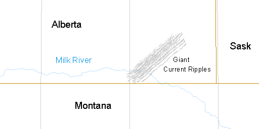 |
| Map showing location of the giant current ripples on the Milk River
Ridge in southeastern Alberta. The canyon of the Milk River transects the
pattern of giant current ripples. |
The ridges are up to 25 m high, with relief decreasing to 1-2 m in the
northwest. The crest to crest wavelength was 405 m in the northwest, increasing
to 1,300 m in the southeast. Flutings oriented northwest to southeast were
superimposed on the ridges. Troughs between the ridges contain wetlands
and small elongated lakes.
Estimated flow rates during the formation of these features were 106
to107 m3/sec. Water depths of from 10 and 60
m were invoked. The mechanism for the formation of these features proposed
by the writer is similar to that described by Beaney and Shaw but without
the ice sheet "lid." Again, in my theory, these features are consistent
with a flood event generated by tectonic uplift of submerged regions, either
in the area of Hudson Bay or now exposed in the Canadian Shield.
References:
Beaney, C.L. and J. Shaw, 2000. The subglacial geomorphology
of southeast Alberta: evidence for subglacial meltwater erosion. Canadian
Journal of Earth Sciences, 37, 51-61.
Coleman, A.P. 1941. The Last Million Years,
U. of Toronto Press.
Cox, D.E. For a critique of the subglacial flood
mechanism, see: Drumlins
and subglacial meltwater floods. Additional information can be
found in: The Glacial
Paradox. (PDF file)
Munro, M. & Shaw, J. 1997. Erosional origin
of hummocky terrain in south-central Alberta, Canada. Geology, 25(11)
p. 10277-1030.
Shaw, J. & D. Kvill 1984. A glaciofluvial origin
for drumlins of the Livingstone Lake area, Saskatchewan. Canadian Journal
of Earth Sciences 21, 1442-1459.
Winslow-Spragge, L. 1962. Life and letters
of George Mercer Dawson 1849-1901
© 1999, 2001 by Douglas E. Cox
The Creation
Concept
 Some
of the most impressive evidence for large scale catastrophic flooding is
the streamlined drumlin field located in the Livingstone Lake area of northwestern
Saskatchewan, that was described by Shaw and Kvill [1984].
Shaw and Kvill proposed a mechanism for flooding involving subglacial melt
water that accumulated beneath a hypothetical ice sheet.
Some
of the most impressive evidence for large scale catastrophic flooding is
the streamlined drumlin field located in the Livingstone Lake area of northwestern
Saskatchewan, that was described by Shaw and Kvill [1984].
Shaw and Kvill proposed a mechanism for flooding involving subglacial melt
water that accumulated beneath a hypothetical ice sheet.